
Public Health
In health geography, I have applied spatial data analysis to understand the relationships between consumer behavior, health outcomes, and urban environment accessibility. Notably, I contributed to a research project examining the presence and magnitude of the Modifiable Areal Unit Problem at various levels of geographic data aggregation in Ontario Health Central, aiming to optimize data utility for health services planning.
The Impact of Changes in Party Political Control in England on Care Home Quaility
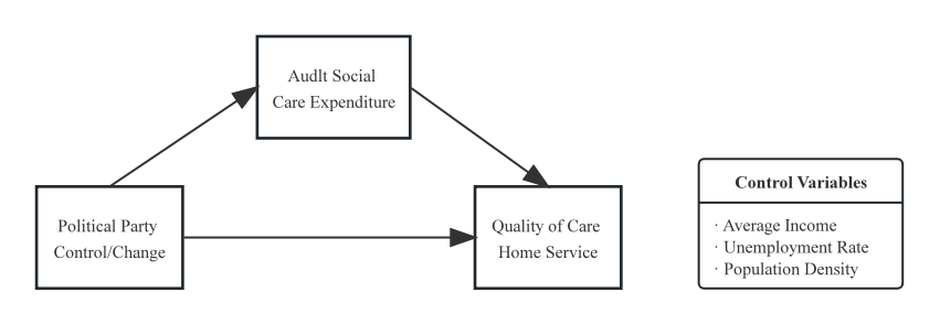
This study investigates the influence of local political dynamics on the quality of care homes in England between 2016 and 2023. Drawing on a balanced panel of 116 local authorities, it integrates Care Quality Commission ratings with local government financial and socioeconomic data. Employing a parallel process latent growth model within a Bayesian framework, the analysis tests both the direct effects of long-term party control and party alternation, as well as the mediating role of per capita adult social care expenditure. The findings reveal that long-term partisan structures exert no statistically significant influence on care home quality, suggesting a potential tendency toward political inertia under stable governance. By contrast, political alternation, specifically a transition from Conservative to Labour control, has a robust and positive effect on quality improvement. Importantly, these effects are not mediated by changes in expenditure, indicating that fiscal input alone does not explain political impacts on service outcomes. Instead, the administrative shock of turnover emerges as the key mechanism driving change. The study contributes to debates on public service performance by challenging the assumption of a “spending–quality” pathway and highlighting the independent role of political reorientation. Beyond the UK, the findings have comparative relevance for welfare states with decentralized governance, offering insights into how local politics shape institutional quality and social care provision.
Assessment of the presence and magnitude of Modifiable Areal Unit Problem atvarious levels of geographic data aggregation in Ontario Health Central

This study used disease data provided by the OCHPP and census data from Statistics Canada to conduct Multivariate Regression Analysis and Predictive Analysis on 366 neighbourhoods in southern Ontario. The results indicate that significant predictors at different geographic levels are distinct, and that a model from a high aggregation level will not be able to accurately predict the dependent variable at a low aggregation level, but vice versa. Furthermore, as the levels of aggregation increase, there is only an increase in correlation between a few variables and others being weakened.